Leaderboard
Popular Content
Showing content with the highest reputation on 03/26/2020 in all areas
-

New to Hazzard Net
Hobie Hartkins and one other reacted to RogerDuke for a topic
LOL This is good news. Since the cop is busy following you the rest of us in town can get away with anything we want.2 points -

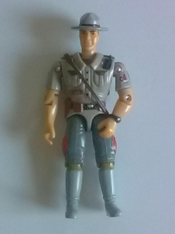
Choctaw Sheriff Emmett "Hammerhand" Ragsdale WIP
Hobie Hartkins reacted to Flint Duke for a topic
Ok, so I am home from work (forced closure due to Corona Virus Governor directive). I've been working on a bunch of projects. This is a WIP (Work in Progress) of a 1:18 scale figure for Sheriff "Hammerhand" Ragsdale. This is the parts I've put together from various figures to work with. I need to do some sanding on the body, then add his bracelet and sheriff stars. Then he will need to be painted up. I also need to fabricate his extra gun belt and straps and possibly paint some pistols. Comments and Criticisms welcomed. I'm hoping to have this completed by the end of the weekend.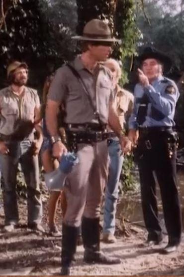
 1 point
 -

Choctaw Sheriff Emmett "Hammerhand" Ragsdale WIP
Flint Duke reacted to Hobie Hartkins for a topic
That is AWESOME!! I always liked good ol' Hammerhead...uh hand! ( You will remember Rosco's and the sheriff's brief conversation over the CB)1 point -
Choctaw Sheriff Emmett "Hammerhand" Ragsdale WIP
Flint Duke reacted to RogerDuke for a topic
That is so cool! Thanks for sharing it and keep us updated on that and any other Dukes stuff you have going on.1 point -

Coronavirus
Hobie Hartkins reacted to Spike for a topic
Well here in Ohio the governor basically said Shelter in place which started midnight this morning. My wife's work is one of the business's not shutting down because they are making some kind of doohickey for Hospitals though after they fill their latest order the boss might shut it down for a week or two. We've taken some time off working for my cousin since one of the businesses we clean the employees travel all over the world and we just don't feel safe cleaning the offices at this time. Saturday we had to go to 4 stores just to fill this week's grocery list The last stores that were open for 24 hours in town finally scaled back their hours to just 12 hours a day to mitigate the panic buying. Sad part is even though stores are limiting certain products to 1 or 2 per customer people are still finding ways around that by either going in multiple times or using their kids or hitting all the stores for the same product. I was chatting with one store employee when we were waiting in line for the store to open and we were talking about the milk panic buying the other day and one of the panic buyers happened to chime in saying they needed all that milk for their business, then it got kind of ugly with the crowd so the topic got changed to calm things down. Hopefully with this shut in order maybe the stores can restock their shelves. Stay safe and Healthy everyone. Thank god we all have Hazzard county to escape too every once and a while.1 point -

New to Hazzard Net
deli rentacop frontage rd reacted to HossC for a topic
I had to laugh at my notifications the other morning - one of them said "deli rentacop frontage rd is now following you". It's not the first another member has followed me, but it's the first time I've felt like I was under police surveillance! I'll have try a little shuck and jive to lose my tail, and if that doesn't work, maybe I'll jump the creek .1 point -
The Patrol Cars In Pictures
Flint Duke reacted to RogerDuke for a topic
I wish Spike would have been in more episodes. I would have loved seeing him do a little body work on Rosco's patrol car.1 point -
Map of Hazzard County
Flint Duke reacted to HossC for a topic
I found this map in 'Duke vs. Duke' from season 3. Bo is showing Daisy which route he'll use in the race on Luke's map. In the episode the map appears upside-down, so the first thing I did was rotate it. It didn't take long to realise that the map looked familiar. It looks like a copy of the same map used in 'Double Dukes', but with different hand written names (you can see that map a few posts back where I identified Redding, CA. as the real Colonial City). On the right is what looks like 'Drexel County', which is a new one to me. Other names that are readable are Shelby Road, Chalk Hill, Partridge? Farm, (unclear) Indian Caves, (unclear) Gulch and (unclear) Practice Area. Maybe someone with better eyes than me can identify some more. Here's the real map of where California meets Oregon and Nevada. You can see it for yourself on Google Maps. In the top map Bo's finger would be about halfway between the two 139s at the bottom of this map.1 point
